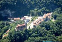

The fishing village of Lastres, located on the eastern coast of Asturias and washed by the Cantabrian Sea, is one of the most picturesque and charming towns in northern Spain.
Nestled between cliffs and green hills, Lastres combines fishing tradition, history, and unique seascapes.
This town reached its peak in the 17th century, although its fishing activity is documented as far back as the 13th century. The village had a significant fleet dedicated to catching tuna, sardines, hake, and even whales, which supported a thriving pickling industry that supplied the regions of León and Castile.
🔹San Roque Viewpoint: Unforgettable Views
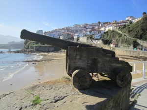
One of the most emblematic spots in Lastres is the San Roque Viewpoint, next to the chapel of the same name.
From here, you can enjoy the best views of the village, with the fishing port at your feet, La Griega Beach in the distance, and the Sueve Range as a scenic backdrop.
An ideal place for taking photos and enjoying the Asturian sunset.
🔹What to See in Lastres
In addition to the viewpoint, Lastres has a remarkable historical heritage:
- 🕍 Parish Church of Santa María de Sábada (1757), declared a Monument in 1992
- ⛪ Chapel of Buen Suceso (17th century)
- ⛪ Chapel of San José (17th century)
- 🕰️ Clock Tower (18th century, with origins in the 15th century)
- ⚓ Traditional fishing port, still in operation
- 🌊 Cobblestone streets and balconies with sea views
🟢 Official Recognition
In 2010, Lastres was awarded the Exemplary Town of Asturias Prize, granted by the Princess of Asturias Foundation, in recognition of its conservation, historical values, and community life.
tag: lastres – following area