

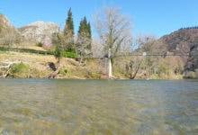
 Llovio Bridge – Sella River (Km 16)
🔹 Useful Technical Information:
📍 Distance from Arriondas: 16 km (Long Route)
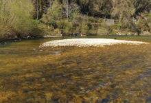
🎣 Fishing Zone: Salmon preserve (from the Santianes weir to the tail of the Infierno pool)
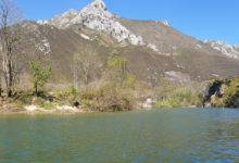
🌊 Section Type: Underpass beneath a road bridge with channeled flow
✅ Ideal for: Reference point at the end of the preserve, careful navigation at low tide
📝 Section Description:
Llovio Bridge, at km 16 of the Sella River, marks the end of the Sella Canoe Descent and is one of the last technical points of the middle section before transitioning to the more open areas near the estuary.
This is a fixed-structure railway bridge used by trains, serving as a landmark for both paddlers and anglers.
Passing under the bridge depends on river levels. At low tide, the flow narrows and the level drops, exposing rocks beneath the arches. At high tide or after rain, the passage is much smoother.
This section remains within the salmon fishing preserve and is often used as a reference endpoint for anglers finishing their day from upstream areas.
Sella Canoe Descent:
From the Banks of the Sella River:
tag: river sella descent by canoe / kayak – descenso del sella en canoa / kayak – fishing ground – coto de pesca
3 Comments