

📌 Sella River Live Water Level: Flow and Floods
The Sella River is one of the most closely monitored rivers in Asturias due to its importance for canoeing, fishing, and the safety of riverside towns. Thanks to the Automatic Hydrological Information System (SAIH), we can know in real time the depth and flow of the Sella River.
🚦 Safety thresholds for the Sella Descent from Arriondas
- ⛔ Over 1.65 m: activity prohibited for safety reasons.
- ⚠️ Between 1.40 and 1.65 m: only allowed with authorized guides.
- ✅ Below 1.40 m: free and safe descent.
🌊 Floods and surges in the Sella River
In autumn and winter, floods and surges are common due to heavy rains. These rises in water level create a natural spectacle but also demand caution. Ribadesella and Arriondas have safety protocols when the Sella reaches risk levels.
📈 Real-time data
Check the virtual gauge for the river level at the main stations: Arriondas, Cangas de Onís, Fuentes, Santianes, and tributaries such as the Piloña and Güeña rivers.
The initial data comes from the Sella River station in Arriondas. Click on the “Sella River in Arriondas” station to select other stations.
🌊 Virtual Gauge
Today summary
Thresholds
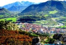
We show you a gallery of images featuring some floods in the Sella River basin:
tag: rio sella niveles de aguas / river sella water levels


One Comment